


Intro: Decreasing water levels have eased immediate lake burst fears, but authorities keep monitoring due to unstable terrain.
Beijing
A new danger has emerged in the flood-hit area along the China-Nepal border after a glacier collapse created two potentially dangerous lakes, raising concerns about further flooding in the region. Chinese authorities said on Saturday that the immediate threat from one lake has eased as water has gradually drained away.
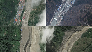
Satellite imagery showed that the surface area of the first lake had fallen by about 21,000 square metres to around 99,000 square metres by Saturday. The shrinking water body has reduced fears of an immediate lake burst, although authorities continue to closely monitor the situation because unstable terrain remains a concern.
However, officials have identified another and larger lake below the site of the glacier collapse. Its surface area has exceeded 120,000 square metres, and its depth remains unclear. The second lake could pose a further threat if water levels rise or natural barriers holding back the water fail. Monitoring teams have been deployed to assess the lakes and surrounding terrain.
The lakes formed after a major glacier and rock collapse triggered devastating flooding earlier this week. The resulting torrent of mud, ice, rocks and debris swept through areas on both sides of the border, destroying infrastructure and cutting off access to several communities. Rescue operations have been complicated by difficult terrain, damaged roads and the continuing risk of secondary disasters.
Chinese authorities reported seven deaths and 554 people missing in the affected area, while hundreds of residents and tourists have been evacuated. Rescue teams are continuing searches as officials monitor the lakes and other unstable areas. The disaster has highlighted the growing risks faced by Himalayan communities from sudden glacier collapses and glacial lake outburst floods.